Straight Outta Conifer (to Snowmass)
Every Summer, my buddy Jamie Kripke organizes a ride from his house in Boulder, CO to his condo in Snowmass, CO. And every summer I find some excuse to not join. Until Summer 2019. I finally wised up and committed. So on June 29, 2019 myself, Jamie, Rich Rodgers, Rudy Verner and Andy Burgess started the trek.

The route was mostly paved with several large sections of dirt. I kept my setup lean with everything I’d need to get to Snowmass, but was able to give Jamie a bag to have waiting there for me ahead of time.
On the front I loaded an Apidura Expedition bar bag with a change of clothes for night 1 and a fresh kit for day 2. I loaded the Accessory Pocket with food, headlamp, water purifier, tools, tubes and any other essentials. My Firefly Allroad has Schwalbe G-Ones (size 40s) on Enve SES AR4.5s (DT Swiss hubs) along with an Enve bar, stem and fork. Fabric saddle and bar tape, full Shimano XTR mtb pedals and Dura Ace mechanical groupset, Cane Creek headset, Silca frame pump and a Garmin 1030.

Day 1
The plan was to depart from Jamie’s house in Boulder on Saturday, June 29, 2019. Since I live an hour (by car) south of Boulder, I decided to leave from my house in Conifer, CO, meet my buddy, Rich Rodgers in Evergreen and ride together to meet the rest of the crew in Idaho Springs around 9am.

Shadow Mountain Road in Conifer, CO
I left my house around 5:30am. The weather was ideal. Chilly to start, but warmer temps awaited. My start is a climb up to the top of Shadow Mountain Road and then a long descent into the town of Evergreen. I met Rich at the coffee shop by the Evergreen Lake. We rode the bike path along the parkway until we hit the Elk Meadows Open Space. From there the path turned to dirt as we climbed to Squaw Pass Road.

Rich in the Elk Meadow Open Space; Evergreen, CO
Squaw Pass is a popular climb for those who live along the front range of the Rockies. The full climb is 18 miles to Echo Lake before you descend into Idaho Springs or continue to climb up to summit the 14,000 feet and change of Mt Evans. I’ve ridden Squaw a bunch, but for this route, Rich and I discovered another option that we’d heard about, yet never tried, or for that matter, noticed. Little Bear Creek Road is dirt road around nine miles up Squaw Pass on the right and also descends to Idaho Springs. No brainer - we had to try this new route.
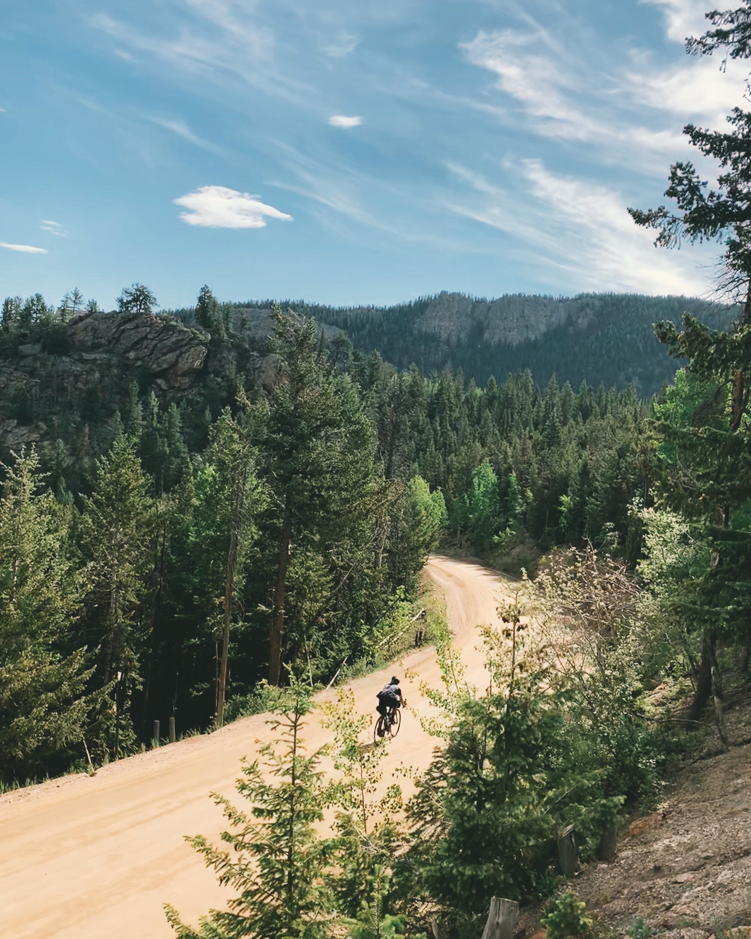
Rich descending Little Bear Creek Road to Idaho Springs, CO
OMFG - where has this road been all my life. Let’s just say I went back and rode it the next two weekends in a row. Seven miles of quiet, backwoods dirt with two sets of hairpin switchbacks that ends just outside of the south side of downtown Idaho Springs. Rich and I were planning to meet the rest of the Boulder crew at The Frothy Cup around 9am. We arrived just before 9 and close to 40 miles and ready for breakfast to refuel.
Around 9:15 Jamie arrives. From Boulder to The Frothy Cup was around 40 miles and they too descended a dirt road into town. The issue was Jamie was solo. Rudy and Andy arrived about 20 minutes later due to Andy puncturing his tire and cracking his rim’s sidewall. He managed to make it to the coffee shop and we reevaluated the odds of anything major happening. The obvious consensus was in - fuck it - let’s roll and see what happens.
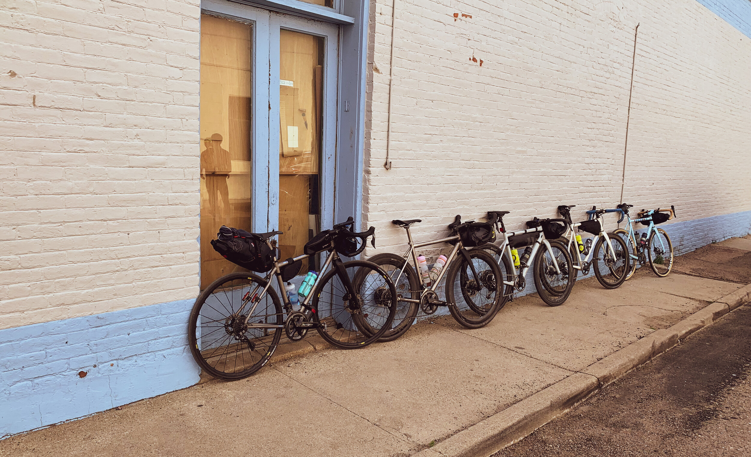
Downtown Idaho Springs, CO
Before we set off, we had to take a group photo and drool at each others steeds. This lineup was ridiculous. A Moots, Firefly, Mosaic, Santa Cruz and Speedvagen. If this ride kicks our asses, we’ll be high rolling either way.
The next chunk of the ride was pretty boring, but a great time to catch up with the full crew. It meanders along I-70 via frontage roads and a bike path until we get to Loveland Pass. Our pace was “chill-but-let’s-get-over-Loveland-before-any-chance-of-an-afternoon-storm-hits.” We did, however, stop in Silver Plume at a rad new coffee shop, called Plume Coffee Bar. A hidden gem for quick espresso in a tiny mining town.

I-70 Frontage Road

Plume Coffee Bar - Silver Plume, CO
Fully caffeinated, we pressed on towards the first major mountain pass of the day and not too breezy of a bike path to get there. The path is empty but loaded with short punches. Then there’s Loveland Pass. Comparable to any Cat 1 climb in the Alps, however, throw in a handful of semi trucks and a wall of traffic behind them with no shoulder and I’d feel ok rating it “HC.” The weather was in our favor at (just shy of) 12,000 feet when we summited and made sure to hit the natural spring just after Arapahoe Basin ski area to fill our bottles.

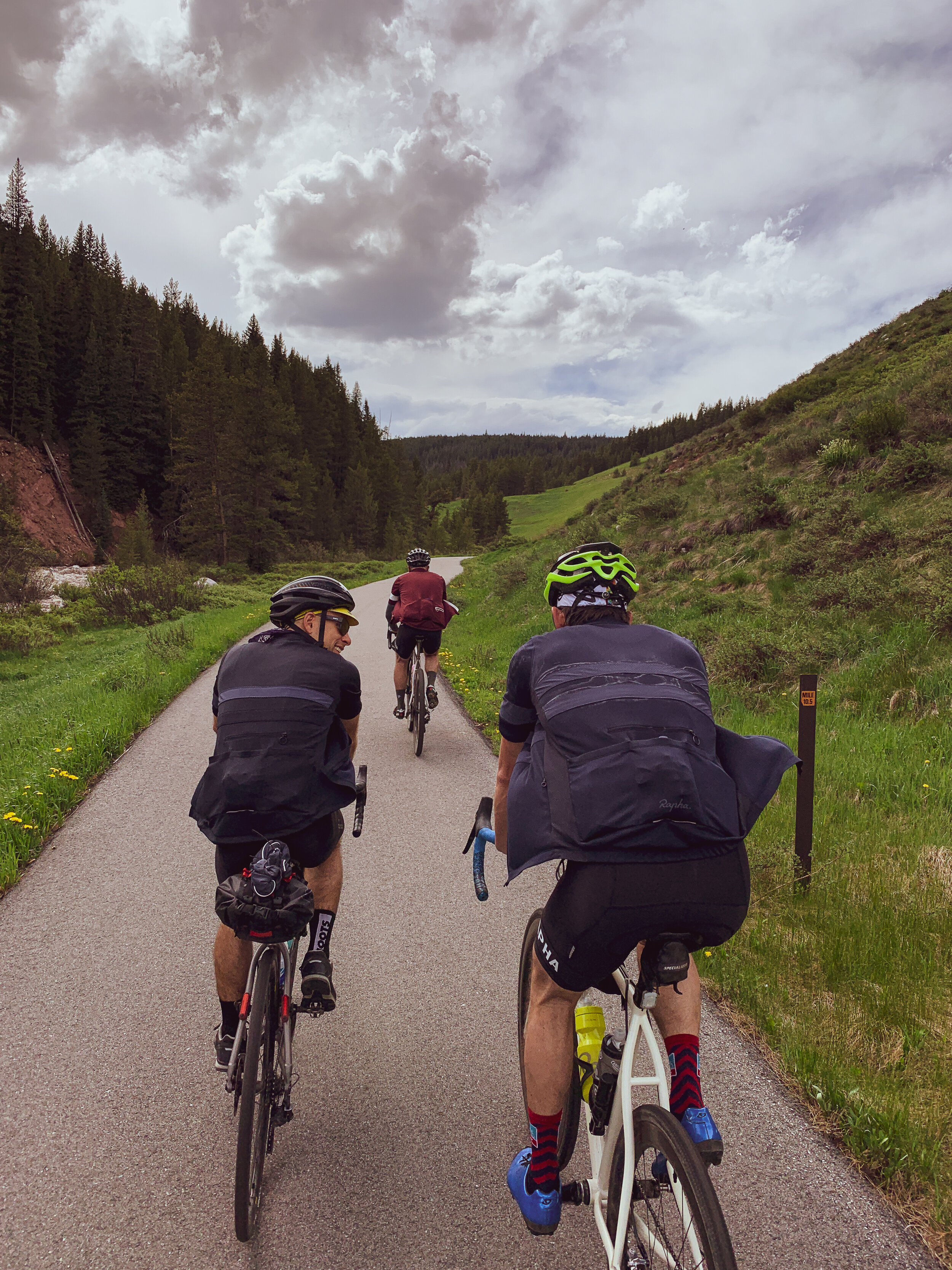
Andy and Jamie on the bike path

Summit of Loveland Pass
After descending into Keystone we had two passes left for day 1. The short - Swan Mountain Pass - and the longer - Vail Pass and throw in the fact that we were over 75 miles in before we hit Swan Mountain. The legs were still working ok over Swan and from there we took the bike path into Frisco. After a quick refueling, we hopped back on the bike path to Copper Mountain where the base of the Vail Pass path begins. The path system throughout the mountains is crucial and well maintained so you never have to ride on the interstate.

Andy and Jamie filling bottles

Path from Frisco to Copper Mountain
Climbing Vail Pass
Vail pass tops out at 10,666 feet with an eighteen mile descent into east Vail via bike path. We took frontage roads and bike paths into Vail Village and called it a night. Day 1 was 111 miles and over 10,112 feet of climbing and Andy’s wheel held up like a champ.
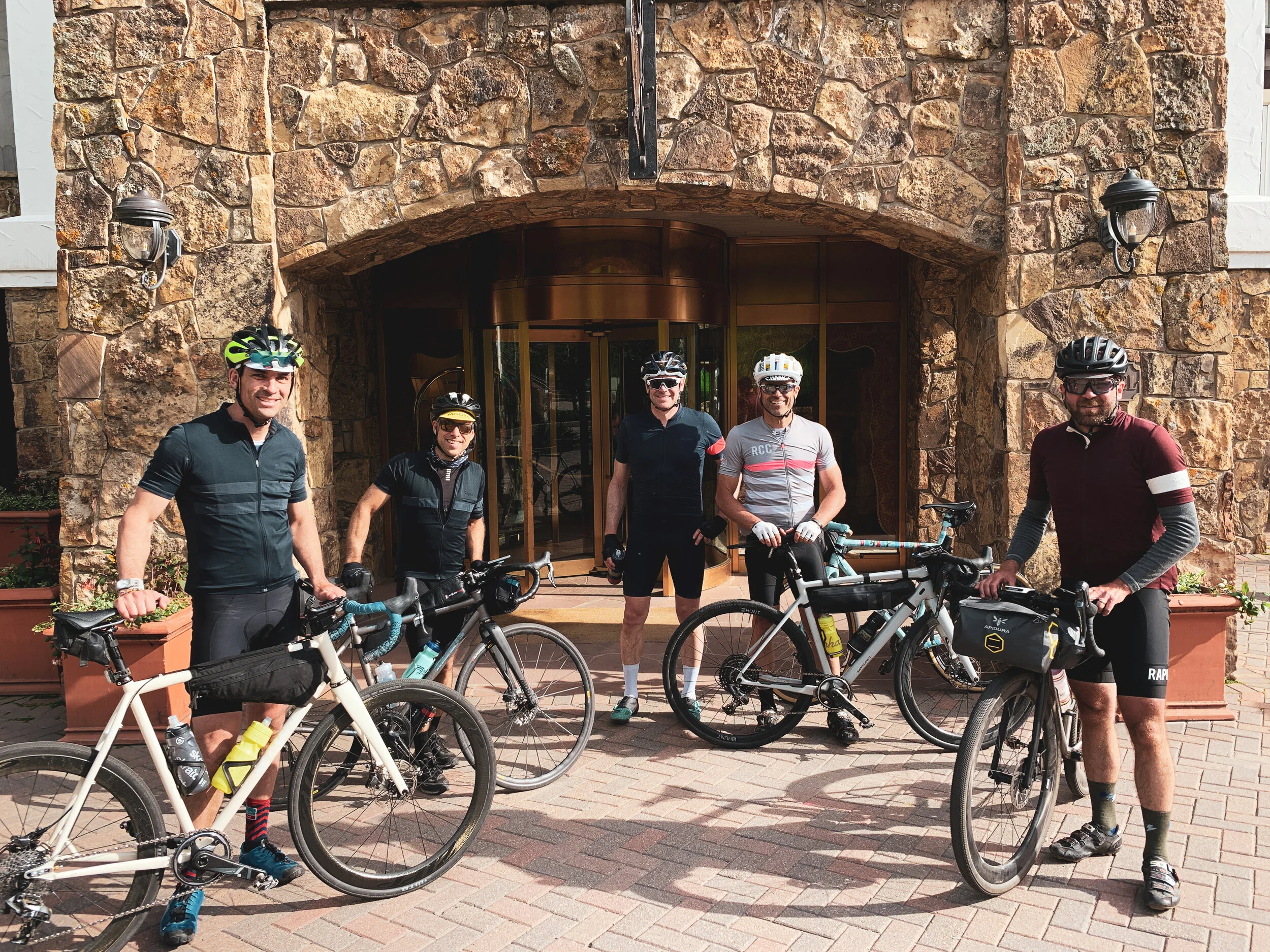
Vail Village. End point for Day 1
Day 2
I was a little sluggish to throw on a fresh kit for another century, but after breakfast and learning that the first thirty miles or so would be mostly descending to Gypsum, I felt ready to roll. Plus Andy’s wheel held air all night so, fingers crossed, this was no longer a potential problem. Besides Little Bear Creek Road, I’d ridden everything at least once from yesterday. Today was the day I was really looking forward to with lots of new terrain.
We departed around 9am. Rolled the frontage roads from Vail to Minturn to Eagle Vail to Avon and stopped in Edwards for some minor adjustments on Rudy’s Speedvagen. I work in Edwards so that was a little side accomplishment to now say I’ve ridden from home to work. From Edwards we passed Wolcott then landed in Eagle for our first “planned” stop at Color Coffee for espresso and breakfast burritos. This was the last real stop before we jumped over to Gypsum and then headed into the backcountry to tackle Cottonwood Pass.

Jamie at the start of Cottonwood Pass Road; Gypsum, CO
Colorado has two Cottonwood Passes. One that connects Buena Vista to Crested Butte and this one from Gypsum to Carbondale. This was the first time taking this road for me so everything felt surreal. It's comprised of road to chip seal to gravel to road - 25 miles in length and roughly 2,000 feet of climbing.

Andy on Cottonwood Pass

Jamie on Cottonwood Pass

Rich on Cottonwood Pass

Jamie on Cottonwood Pass
The descent starts on gravel then finishes on fresh paved black top into the Roaring Fork Valley dumping you out at the Catherine Store (via Catherine Store Road). The Catherine Store is a gas station/liquor store that has plenty of snacks and booze on the southend of Carbondale. We refueled and Rudy, Jamie and myself pushed on. Rich and Andy felt the need to take an alternate route, tacking on an extra twenty miles and 2,000 feet of climbing.

Andy descending Cottonwood Pass to Carbondale with Mt. Sopris in view

The Catherine Store; Carbondale, CO

Rudy on East Sopris Creek Road; Old Snowmass, CO

Rudy and Jamie; Snowmass Creek

Jamie on Snowmass Creek Road

Myself struggling up the backside of Snowmass Resort (Pic: Jamie)

Jamie’s face says it all
We beat the approaching storm. Rich and Andy, however, did not. They arrived soaked and questioning their choice to add on miles, but in the end we all made it trouble-free and ready to set a date to do it again next year. Day 2 was 90 miles and 6,000 feet of climbing. Oh and hats off to Andy Burgess. He woke up the next morning and rode back to Boulder.
Why is this one helluva ride? For the route I took the combo of Little Bear Creek Road plus Cottonwood Pass plus East Sopris and Snowmass Creek Roads were a gravel rider’s dream.